
Elevation Services

Several years ago, I programmed elevation services to compare the accuracy of the National Elevation Dataset (NED) and the Advanced Spaceborne Thermal Emission and Reflection Radiometer (ASTER) Digital Elevation Model (DEM) V1 & V2 against elevation recorded by hand held GPS receivers, wearable devices and altimeters. This document explains why elevation services require accurate points as input to return accurate elevation values; this is something that smartphones —especially those that employ geofencing— can not always provide. This document also explains why —even with the most accurate points— most elevation services return elevation values with limited accuracy.
Vertical Accuracy
The overall absolute vertical accuracy expressed as the root mean square error (RMSE) of the ASTER DEM V2 is 8.68 m (28.47 ft). RMSE is a statistic that is calculated by comparing the DEM with known elevation points (control points). It provides an assessment of how well a DEM corresponds to the data from which it was generated. An RMSE of 28.47 ft is a range within which we may expect the true elevation to exist. However, while the RMSE is an interesting statistic, it does not provide an accurate assessment of how well each cell in the DEM represents the bare earth elevation. The ASTER stereo-pair images record reflective surfaces which include the tops of trees and buildings. The ASTER DEM may be vertically inaccurate by hundreds of feet where these reflective surfaces are located.
The overall absolute vertical accuracy expressed as the RMSE of the NED is 2.44 m (8.00 ft). The USGS describes the NED accuracy as follows, "The accuracy of the National Elevation Dataset (NED) varies geographically because of quality differences among the source digital elevation models (DEMs). The NED accuracy at any particular location is influenced by the currency, resolution, and production method of the source DEMs in that location." While the overall absolute vertical accuracy of the NED expressed as the RMSE is 8 ft, the control points that were used in this statistic do not completely represent the U.S. topography. The RMSE is based on 13,305 geodetic control points, they are concentrated in the eastern United States and are located in open, accessible areas. High elevation, steep slope locations are under-represented.
Horizontal Resolution
It is just as important to understand the horizontal resolution of a DEM as the vertical accuracy. Horizontal resolution is the cell size of the earth area that an elevation post represents. The ASTER DEM V2 has a 1-arc-second resolution which is 30 m (98.42 ft) that covers an area of 9,686.49 sq ft. The 10m NED has a 1/3-arc-second resolution which is 10 m (32.80 ft) that covers an area of 1,075.84 sq ft. This means that elevation services using the ASTER DEM V2 can provide only one elevation value for a ~9,686 sq ft area. Elevation services that use the 10m NED can provide only one elevation value for a ~1,075 sq ft area.
Accurate Points
The black dashed-line in Figure-A represents a section of trail (which traverses a slope) that was recorded using a hand held GPS receiver. The trail has 40 different points. If a 30m ASTER DEM elevation service uses these points to determine the trail's elevation then all 40 points will have the same elevation value, as all of the points are located within one elevation post covering a 9,686 sq ft area. If a 10m NED elevation service uses the same points to determine the trail's elevation then the 40 different points are paired with only five different elevation values (located in cells G, H, E, F and C). Note, none of the 30m ASTER DEM and 10m NED cells are guaranteed to be accurate within an acceptable range for the reasons described above.
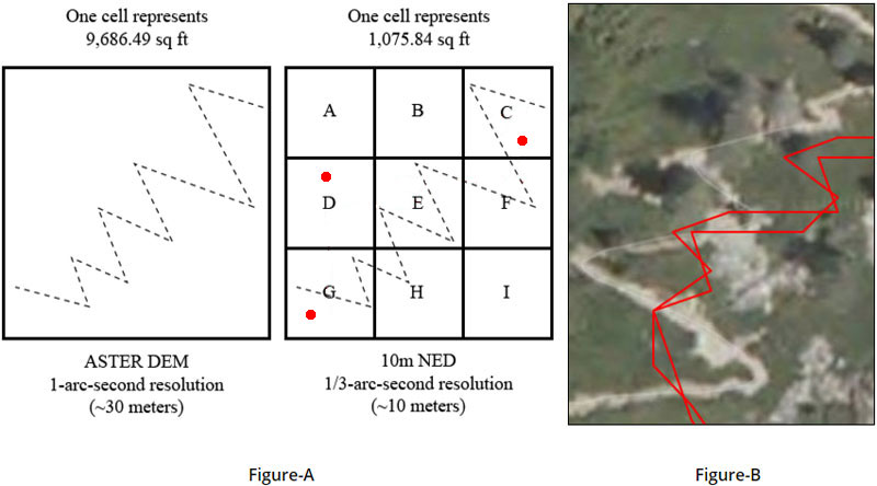
Inaccurate Points
The same section of trail was recorded by a smartphone and the geofenced points are represented in Figure-A with three red dots. If a 10m NED elevation service uses the smartphone's points to determine elevation then there are only three different elevation values, as the track is geofenced. However, at least one of these inaccurate points (cell D) represent a location that is over a hundred feet away from where the trail is actually located (which is in cells H, E and F); the smartphone software did not immediately detect when the geofence was breached. The elevation value (cell D) could be 10, 100 or maybe even 1,000 or more feet lower or higher than where the trail is actually located.
The image in Figure-B is an example of a trail that was recorded by a smartphone. Notice the positional inaccuracies compared to the orthoimagery. The trail is similar to the example in Figure-A. Elevation services require accurate points as input to return accurate elevation values; even with the most accurate points, most elevation services return elevation values with limited accuracy.