Appalachian Trail

The Appalachian Trail is located in the eastern United States extending between Springer Mountain in Georgia and Mount Katahdin in Maine.
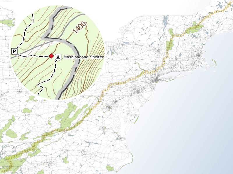
Trails National Scenic Trails Appalachian
AT
The Complete AT Map Set

182 maps for GPS tracking, in free apps
Complete trail from Georgia to Maine
1:24k topographic map base layer
Includes shelters and parking
Learn More

Section 001 - Springer Mountain - AT Map Georgia (GA)
Section 002 - Cooper Gap - AT Map Georgia (GA)
Section 003 - Neels Gap - AT Map Georgia (GA)
Section 004 - Tesnatee Gap - AT Map Georgia (GA)
Section 005 - Unicoi Gap - AT Map Georgia (GA)
Section 006 - Dicks Creek Gap - AT Map Georgia (GA)
Section 007 - Blue Ridge Gap - AT Map North Carolina (NC)
Section 008 - Mooney Gap - AT Map North Carolina (NC)
Section 009 - Winding Stair Gap - AT Map North Carolina (NC)
Section 010 - Tellico Gap - AT Map North Carolina (NC)
Section 011 - Wesser - AT Map North Carolina (NC)
Section 012 - Stecoah Gap - AT Map North Carolina (NC)
Section 013 - Fontana Dam - AT Map North Carolina (NC)
Section 014 - Thunderhead Mountain - AT Map North Carolina (NC)
Section 015 - Silers Bald - AT Map North Carolina (NC)
Section 016 - Clingmans Dome - AT Map North Carolina (NC)
Section 017 - Icewater Spring - AT Map North Carolina (NC)
Section 018 - Tricorner Knob - AT Map North Carolina (NC)
Section 019 - Davenport Gap - AT Map North Carolina (NC)
Section 020 - Groundhog Creek - AT Map North Carolina (NC)
Section 021 - Roaring Fork - AT Map North Carolina (NC)
Section 022 - Hot Springs - AT Map North Carolina (NC)
Section 023 - Little Laurel - AT Map North Carolina (NC)
Section 024 - Flint Mountain - AT Map North Carolina (NC)
Section 025 - Bald Mountain - AT Map North Carolina (NC)
Section 026 - Chestoa - AT Map North Carolina (NC)
Section 027 - Cherry Gap - AT Map North Carolina (NC)
Section 028 - Iron Mountain - AT Map North Carolina (NC)
Section 029 - Carvers Gap - AT Map North Carolina (NC)
Section 030 - Evergreen - AT Map Tennessee (TN)
Section 031 - Laurel Fork - AT Map Tennessee (TN)
Section 032 - Watauga Lake - AT Map Tennessee (TN)
Section 033 - Cherokee National Forest - AT Map Tennessee (TN)
Section 034 - McQueen Knob - AT Map Tennessee (TN)
Section 035 - Holston Mountain - AT Map Tennessee (TN)
Section 036 - Damascus - AT Map Virginia (VA)
Section 037 - Lost Mountain - AT Map Virginia (VA)
Section 038 - Hurricane Mountain - AT Map Virginia (VA)
Section 039 - Quebec - AT Map Virginia (VA)
Section 040 - Atkins - AT Map Virginia (VA)
Section 041 - Brushy Mountain - AT Map Virginia (VA)
Section 042 - Medley Valley - AT Map Virginia (VA)
Section 043 - Garden Mountain - AT Map Virginia (VA)
Section 044 - Bland - AT Map Virginia (VA)
Section 045 - Point Pleasant - AT Map Virginia (VA)
Section 046 - Jenny Knob - AT Map Virginia (VA)
Section 047 - Sugar Run Mountain - AT Map Virginia (VA)
Section 048 - Pearisburg - AT Map Virginia (VA)
Section 049 - Pine Swamp - AT Map Virginia (VA)
Section 050 - War Spur - AT Map Virginia (VA)
Section 051 - Laurel Creek - AT Map Virginia (VA)
Section 052 - Sarver Hollow - AT Map Virginia (VA)
Section 053 - Cove Mountain - AT Map Virginia (VA)
Section 054 - Catawba Mountain - AT Map Virginia (VA)
Section 055 - Daleville - AT Map Virginia (VA)
Section 056 - Fullhart Knob - AT Map Virginia (VA)
Section 057 - Bobblets Gap - AT Map Virginia (VA)
Section 058 - Bryant Ridge - AT Map Virginia (VA)
Section 059 - Thunder Hill - AT Map Virginia (VA)
Section 060 - Matts Creek - AT Map Virginia (VA)
Section 061 - Brown Mountain Creek - AT Map Virginia (VA)
Section 062 - Hog Camp Gap - AT Map Virginia (VA)
Section 063 - The Priest - AT Map Virginia (VA)
Section 064 - Reids Gap - AT Map Virginia (VA)
Section 065 - Swannanoa - AT Map Virginia (VA)
Section 066 - Calf Mountain - AT Map Virginia (VA)
Section 067 - Blackrock - AT Map Virginia (VA)
Section 068 - Simmons Gap - AT Map Virginia (VA)
Section 069 - Hightop - AT Map Virginia (VA)
Section 070 - Bootens Gap - AT Map Virginia (VA)
Section 071 - Rock Spring - AT Map Virginia (VA)
Section 072 - Pass Mountain - AT Map Virginia (VA)
Section 073 - Gravel Springs - AT Map Virginia (VA)
Section 074 - Compton Gap - AT Map Virginia (VA)
Section 075 - Bear Hollow - AT Map Virginia (VA)
Section 076 - Blue Mountain - AT Map Virginia (VA)
Section 077 - Ashby Gap - AT Map Virginia (VA)
Section 078 - Shenandoah Retreat - AT Map Virginia (VA)
Section 079 - Blue Ridge Acres - AT Map Virginia (VA)
Section 080 - Harpers Ferry - AT Map Maryland (MD)
Section 081 - Turners Gap - AT Map Maryland (MD)
Section 082 - Smithsburg - AT Map Maryland (MD)
Section 083 - Raven Rock - AT Map Maryland (MD)
Section 084 - Rocky Mountain - AT Map Pennsylvania (PA)
Section 085 - Birch Run - AT Map Pennsylvania (PA)
Section 086 - Pine Grove Furnace - AT Map Pennsylvania (PA)
Section 087 - Toland - AT Map Pennsylvania (PA)
Section 088 - Boiling Springs - AT Map Pennsylvania (PA)
Section 089 - Donnellytown - AT Map Pennsylvania (PA)
Section 090 - Duncannon - AT Map Pennsylvania (PA)
Section 091 - Clarks Ferry - AT Map Pennsylvania (PA)
Section 092 - Peters Mountain - AT Map Pennsylvania (PA)
Section 093 - Stony Mountain - AT Map Pennsylvania (PA)
Section 094 - Rausch Gap - AT Map Pennsylvania (PA)
Section 095 - Inwood - AT Map Pennsylvania (PA)
Section 096 - Blue Mountain - AT Map Pennsylvania (PA)
Section 097 - Round Head - AT Map Pennsylvania (PA)
Section 098 - Eagles Nest - AT Map Pennsylvania (PA)
Section 099 - Port Clinton - AT Map Pennsylvania (PA)
Section 100 - Eckville - AT Map Pennsylvania (PA)
Section 101 - Bears Rocks - AT Map Pennsylvania (PA)
Section 102 - Bake Oven Knob - AT Map Pennsylvania (PA)
Section 103 - Palmerton - AT Map Pennsylvania (PA)
Section 104 - Smith Gap - AT Map Pennsylvania (PA)
Section 105 - Wind Gap - AT Map Pennsylvania (PA)
Section 106 - Kittatinny Mountain - AT Map Pennsylvania (PA)
Section 107 - Delaware Water Gap - AT Map Pennsylvania (PA)
Section 108 - Catfish Pond - AT Map New Jersey (NJ)
Section 109 - Rattlesnake Mountain - AT Map New Jersey (NJ)
Section 110 - Culvers Gap - AT Map New Jersey (NJ)
Section 111 - Sunrise Mountain - AT Map New Jersey (NJ)
Section 112 - Lake Marcia - AT Map New Jersey (NJ)
Section 113 - Unionville - AT Map New Jersey (NJ)
Section 114 - Pochuck Mountain - AT Map New Jersey (NJ)
Section 115 - Greenwood Lake - AT Map New Jersey (NJ)
Section 116 - Mombasha Lake - AT Map New York (NY)
Section 117 - Fingerboard Mountain - AT Map New York (NY)
Section 118 - Bear Mountain Bridge - AT Map New York (NY)
Section 119 - Graymoor - AT Map New York (NY)
Section 120 - Canopus Lake - AT Map New York (NY)
Section 121 - Stormville Mountain - AT Map New York (NY)
Section 122 - Nuclear Lake - AT Map New York (NY)
Section 123 - Bulls Bridge - AT Map Connecticut (CT)
Section 124 - Stewart Hollow Brook - AT Map Connecticut (CT)
Section 125 - Pine Swamp Brook - AT Map Connecticut (CT)
Section 126 - Brassi Brook - AT Map Connecticut (CT)
Section 127 - Mount Everett - AT Map Massachusetts (MA)
Section 128 - Mount Wilcox - AT Map Massachusetts (MA)
Section 129 - Higley Brook - AT Map Massachusetts (MA)
Section 130 - Tully Mountain - AT Map Massachusetts (MA)
Section 131 - Dalton - AT Map Massachusetts (MA)
Section 132 - Mount Greylock - AT Map Massachusetts (MA)
Section 133 - Blackinton - AT Map Vermont (VT)
Section 134 - Harmon Hill - AT Map Vermont (VT)
Section 135 - Glastenbury Mountain - AT Map Vermont (VT)
Section 136 - Story Spring - AT Map Vermont (VT)
Section 137 - Spruce Peak - AT Map Vermont (VT)
Section 138 - Peru Peak - AT Map Vermont (VT)
Section 139 - Little Rock Pond - AT Map Vermont (VT)
Section 140 - Cold River - AT Map Vermont (VT)
Section 141 - Pico Camp - AT Map Vermont (VT)
Section 142 - Stony Brook - AT Map Vermont (VT)
Section 143 - Bridgewater Hollow - AT Map Vermont (VT)
Section 144 - Thistle Hill - AT Map Vermont (VT)
Section 145 - West Hartford - AT Map Vermont (VT)
Section 146 - Velvet Rocks - AT Map New Hampshire (NH)
Section 147 - Moose Mountain - AT Map New Hampshire (NH)
Section 148 - Smarts Mountain - AT Map New Hampshire (NH)
Section 149 - Jeffers Brook - AT Map New Hampshire (NH)
Section 150 - Beaver Brook - AT Map New Hampshire (NH)
Section 151 - Lonesome Lake - AT Map New Hampshire (NH)
Section 152 - Garfield Ridge - AT Map New Hampshire (NH)
Section 153 - Zealand Falls - AT Map New Hampshire (NH)
Section 154 - Mount Webster - AT Map New Hampshire (NH)
Section 155 - Lake of the Clouds - AT Map New Hampshire (NH)
Section 156 - Carter Notch - AT Map New Hampshire (NH)
Section 157 - Gentiar Pond - AT Map New Hampshire (NH)
Section 158 - Goose Eye Mountain - AT Map New Hampshire (NH)
Section 159 - Speck Pond - AT Map Maine (ME)
Section 160 - Hall Mountain - AT Map Maine (ME)
Section 161 - Old Blue Mountain - AT Map Maine (ME)
Section 162 - Bemis Mountain - AT Map Maine (ME)
Section 163 - Sabbath Day Pond - AT Map Maine (ME)
Section 164 - Piazza Rock - AT Map Maine (ME)
Section 165 - Poplar Ridge - AT Map Maine (ME)
Section 166 - Sugarloaf Mountain - AT Map Maine (ME)
Section 167 - Horns Pond - AT Map Maine (ME)
Section 168 - Little Bigelow Mountain - AT Map Maine (ME)
Section 169 - West Carry Pond - AT Map Maine (ME)
Section 170 - Pleasant Pond - AT Map Maine (ME)
Section 171 - Moxie Pond - AT Map Maine (ME)
Section 172 - Bald Mountain - AT Map Maine (ME)
Section 173 - Horseshoe Canyon - AT Map Maine (ME)
Section 174 - Spectacle Ponds - AT Map Maine (ME)
Section 175 - Big Wilson - AT Map Maine (ME)
Section 176 - Chairback Mountain - AT Map Maine (ME)
Section 177 - Logan Brook - AT Map Maine (ME)
Section 178 - Crawford Pond - AT Map Maine (ME)
Section 179 - Cooper Brook - AT Map Maine (ME)
Section 180 - Rainbow Lake - AT Map Maine (ME)
Section 181 - Hurd Brook - AT Map Maine (ME)
Section 182 - Mount Katahdin - AT Map Maine (ME)
AT Map

It's the maps, not the apps that matter.

Subscription Free Trail Maps