
Cartographic Spam
While the most widely recognized form of spam is e-mail spam, the term is applied to other abuses in electronic media, many of which are described at Wikipedia. Cartographic spam is unreliable, inaccurate or false data in digital maps, published with the intention of manipulating search engine indexes and/or the people who view the maps. Cartographic spam is sometimes a type of spamdexing.
One of the functions of a smart phone trail app is to collect geographic points as a person moves along a trail. The points are uploaded to a website associated with the trail app where they are plot over digital maps in a web page. Search engines crawl the web page and index the URL in search results. People who find the web page can download the route to their GPS device and follow the same points. The problem with sharing crowdsourced points: not all routes follow legally constructed trails on public property and the points, when collected at rural locations, are highly inaccurate and geofenced. This doesn't stop some websites from publishing the data however, because each page published is another page indexed by search engines. This is how people find the website—click on it—and the advertisements on the web pages that earn the website advertising revenue.
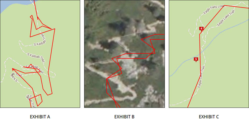
EXHIBIT A: This trail is plot as a solid line with points collected by a smartphone trail app. Google® plot the same trail with a dashed line. The trail app points are highly inaccurate and erroneous. At the time of this writing, the Google first page search results link to the page that displays this trail, in response to a query for "Grand Canyon Trails".
EXHIBIT B: This is an out-and-back trail depicted with points collected by a smartphone trail app. As you can see in the image, the points do not accurately represent the trail in either direction. In addition, it is not possible to calculate accurate trail metrics using these inaccurate points.
EXHIBIT C: This trail is plot as a solid line with points collected by a smartphone trail app. The trail is described as a "Snowshoe Trail". The trail is highly inaccurate. Notice the trail crosses a stream; if a person downloads this trail to a GPS device and follows the points when the ground is featureless (e.g., when there is snow on the ground that covers pools of water and the stream) or visibility is reduced (e.g., during a snow flurry) then death or injury is possible.
For more information, please read: Why Crowd-Sourced Trail Data is Unreliable. This document is an overview of accuracy concerns with the use of crowdsourced trail data.
You can also view more examples of cartographic spam.